Electrical Resistivity Methods
Electrical resistivity is an intrinsic property of all materials.
The properties that affect the resistivity of soil or rock include:
porosity, water content, composition (clay mineral and metal
content), salinity of the pore water, and grain size distribution.
Therefore, the electrical resistivity method is ideally suited to
provide information for ground water surveys and bedrock topography.
The electrical resistivity method is primarily deployed on land.
However, in addition to terrestrial surveys, marine electrical
resistivity surveys can help delineate stratigraphy below a lake
bottom. See our Marine Geophysics page for more information on this
method.
- Determination of stratigraphy
- Groundwater exploration
- Mineral resource exploration
- Sand, gravel and hard rock resource exploration
- Locating fracture zones and voids
- Mapping pollution plumes
- Locating leakage from landfills
- Locating seepage through dams
- Planning grounding grids
In an electrical resistivity exploration, electric current is
applied to the ground surface through two electrodes. Two or three
additional electrodes are placed in the ground to measure variations
in the potential of the electrical field (voltage) that is set up
within the earth by the current electrodes. There are two basic
field procedures which are commonly used in electrical resistivity
exploration:
1) Electrical traversing in which the electrode separation remains
constant during the survey; and
2) Electrical sounding, in which the center of the electrode spread
is maintained at a fixed location and the electrode spacing is
increased in increments.
Electrical traversing is normally employed when a rapid survey of an
area is desired. It is particularly suited for prospecting for sand,
gravel and ore deposits and for locating fault zones or contacts
between steeply dipping layers of earth materials
Electrical sounding is designed to provide information on the
variation in subsurface conditions with depth. Sounding is typically
used to help determine the depth to the water table, the thickness
of sand, gravel and rock layers, and the actual value of electrical
resistivity versus depth.
Traversing and sounding can be combined using a multi-electrode
system. The multi-electrode system consists of over 56 electrodes
and an eight channel resistivity meter that is capable of electronically switching
the electrodes. The data are analyzed with a 2-D or 3-D forward
inverse modeling computer program. In the program, a non-linear
least-squares optimization technique is used to automatically
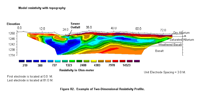
determine the best fit to the data. An example of a two dimensional
electrical resistivity cross-section is shown in the Figure below.

