Precision Buried Utility Locating Services
Precise determination of buried utilities is becoming more important as infrastructure is upgraded and urban areas are more densely developed.
 |
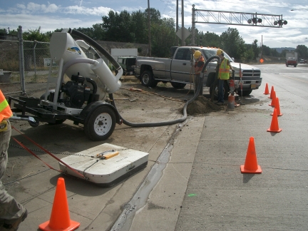
| GPR Locate (foreground) and air/vac excavation (background). |
Earth Dynamics provides precision utility locating services using a variety of techniques. Ground Penetrating Radar (GPR) is capable of detecting and locating metallic and non-metallic underground utilities typically to depths of 15 or 20 feet below the ground surface. Magnetic and electromagnetic methods can be used to locate metallic utilities. The detection depth depends on the size of the utility.
Locations that are identified with geophysical techniques can be confirmed using Earth Dynamics' air/vac excavation system. The air/vac system uses high pressure air to loosen soil and gravel. A high capacity vacuum is used to remove the loosened material. This method does not damage existing utilities and the excavated material is immediately replaced and compacted after the utility has been observed. A typical air/vac pothole is ten to fifteen inches in diameter and may be up to twenty feet deep.
A summary of Earth Dynamics' Utility Locating Services is shown below:
- Locate metallic and non-metallic utilities
- Locate PVC and concrete pipes
- Underground storage tanks
- Mark in the field
- Utility Mapping
- Vacuum potholing
- Install electronic marker balls for easy re-locating and identifying buried utilities
 |
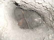
| The image above shows an angle point on a 4" PVC pressurized sewer line five feet below the road surface. The pipe was located using ground penetrating radar and the angle point was potholed for confirmation and marker ball placement. |
